The Travels of a Journalistâ€â€ÂÂ67-We fly from Fargo to San Antonio, then drive to Big Bend National Park on a 9-day adventure of camping.
Posted on May 9th, 2011
By Shelton A. Gunaratne ƒÆ’-¡ƒ”š‚© 2011
Professor of mass communications emeritus at Minnesota State University Moorhead
ƒÆ’-¡ƒ”š‚ Having camped in almost every national park in the West and the Midwest, I turned next to the South. My attention focused on Big Bend National Park located in south Brewster County, Texas. The Big Bend NP encompasses approximately 324,220 hectares. The mammoth size of the park becomes clear when you realize that almost one-quarter of the 1,000 miles of Rio Grande/ River Bravo, which makes up the boundary between the United States and Mexico, flows through the Big Bend territory. Within the 118 twisting miles that also marks the southern boundary of the park, the riverƒÆ’‚¢ƒ¢-¡‚¬ƒ¢-¾‚¢s southeasterly flow turns abruptly to the northeast thereby forming the ƒÆ’‚¢ƒ¢-¡‚¬ƒ…-big bendƒÆ’‚¢ƒ¢-¡‚¬ƒ”š‚ of the Rio Grande.ƒÆ’-¡ƒ”š‚
This geographical layout of Big Bend intrigued my familyƒÆ’‚¢ƒ¢-¡‚¬ƒ¢¢”š¬‚daughter Carmel, 7; son Junius, 11; spouse Yoke-Sim; and meƒÆ’‚¢ƒ¢-¡‚¬ƒ¢¢”š¬‚so much that we decided to skip the rigors of early wintry weather in our neck of the woods in Fargo-Moorhead in late November 1991 to enjoy the warmer sunshine of southwestern Texas for at least nine days.
We left Fargo at 8 a.m. on a Saturday (23 Nov. 1991). Ariyaratna Wijetunga, a faculty colleague of mine, gave us a ride to the Fargo Airport, where we boarded the Northwest flight to Minneapolis. There, we took another Northwest flight to Memphis, Tenn. Then, we boarded yet another Northwest flight to San Antonio (pop. 1.33 million), the second largest city in Texas after Houston.
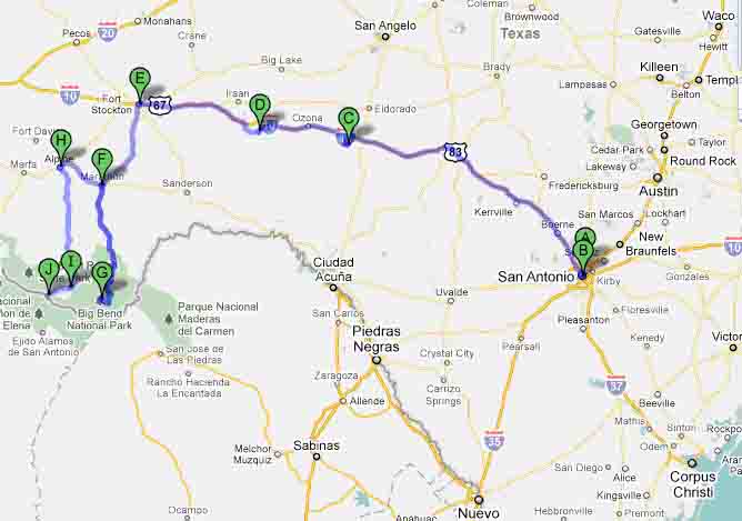
ƒÆ’-¡ƒ”š‚ Figure 1: Our tour route from San Antonio to Big Bend National Park (November 1991):A=San Antonio International Airport; B=Downtown San Antonio; C=Caverns of Sonora; D=Fort Lancaster on scenic highway 290; E=Fort Stockton; F=Marathon; G=Big Bend National Park Service Headquarters; H=Alpine; I=Study Butte-Terlingua; J=Lajitas.
On arrival in San Antonio at 5 p.m., we rented a Ford Taurus automatic from NationalƒÆ’-¡ƒ”š‚® Car Rental. We used this vehicle as our storage and ƒÆ’‚¢ƒ¢-¡‚¬ƒ…-home-away-from-homeƒÆ’‚¢ƒ¢-¡‚¬ƒ”š‚ for the duration of our entire trip. Next, we drove two miles southeast from the airport to Best Western Town House Motel (942 NE Loop 410) to check-in for our overnight stay in Room No. 66. After settling down, we drove a dozen or so miles south and west on New Braunfels Avenue to downtown to buy our food and other camping needs at a Handy Andy supermarket on West Commerce Street.
Sunday morning, we drove some 182 miles northwest on Interstate 10 to Sonora (pop. 3,008), the administrative seat of Sutton County. Our plan was to tour San Antonio after we finished the more exciting exploration of the Big Bend NP.
Because all four of us were cave buffs, we stopped to visit the Caverns of Sonora National Natural Landmark (1711 Private Road 4468), a star tourist attraction on this route, located eight miles west of Sonora. Wikipedia extols the landmark as ƒÆ’‚¢ƒ¢-¡‚¬ƒ…-a world-class cave because of its stunning array of calcite [a carbonate mineral] crystal formations, especially helictites.ƒÆ’‚¢ƒ¢-¡‚¬ƒ”š‚ Having paid a total of $24 for admission, we were happy to join the11.30 a.m. tour of the caves, an exciting 1.5-hour experience that introduced us to an enormous variety of stalactites, the icicle-like elongated mineral formations that hang from the ceilings and sides of limestone caverns; stalagmites, the corresponding formations on the floor of the cavern; and helictites, which usually come out from cave walls horizontally and look like tangles of spaghetti. Jack Burch, a caver from Oklahoma, saw the cavern for the first time in 1956. It has been open to the public since July 1960.
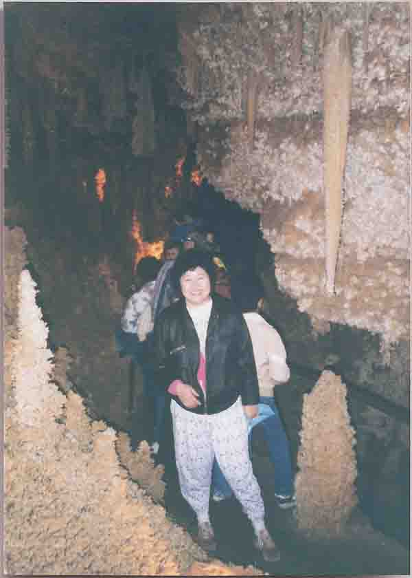
Picture 1ƒÆ’-¡ƒ”š‚ ƒÆ’-¡ƒ”š‚ Yoke-Sim stands by the side of a huge stalactite and a stalagmite during the tour of the Caverns of Sonora (24 Nov. 1991).]
ƒÆ’-¡ƒ”š‚ Back on our way on Interstate 10, about 70 miles west of Sonora, we decided to take a scenic detour on SR 290 to see the 33-hectare Fort Lancaster State Historic SiteƒÆ’-¡ƒ”š‚ in the Pecos River Valley of Crockett County. Established by Captain Stephen Decatur Carpenter on 20 Aug. 1855, Fort Lancaster was one of four forts built along the western Texas frontier ƒÆ’‚¢ƒ¢-¡‚¬ƒ…-to guard the military supplies, commercial shipments, and immigrantsƒÆ’‚¢ƒ¢-¡‚¬ƒ”š‚ (Wikipedia) along the military route between San Antonio and El Paso.
ƒÆ’-¡ƒ”š‚ Then, we got back to I-10 and drove another 80 miles northwest to Fort Stockton (pop. 7,846), where we arrived at 5 p.m. We stayed overnight at Sands Motor Inn (1801 N. Dickinson Blvd.), where Carmel and Junius had a whale of a time in the facilityƒÆ’‚¢ƒ¢-¡‚¬ƒ¢-¾‚¢s heated swimming pool and the Jacuzzi.ƒÆ’-¡ƒ”š‚ We ate dinner at Kentucky Fried Chicken. We also shopped at Wal-Mart to buy various nick-knacks we needed.
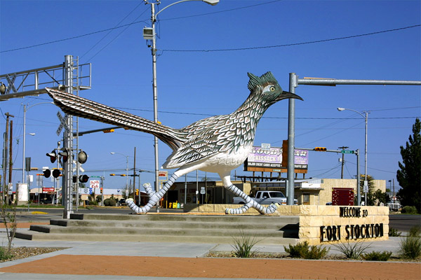
Monday (25 Nov) morning, we toured the Fort Stockton historical district starting from the welcoming figure of Paisano Pete, then the worldƒÆ’‚¢ƒ¢-¡‚¬ƒ¢-¾‚¢s largest (10 ft. tall and 22 ft. long) roadrunner (now demoted to second place by a challenger in Las Cruces, N.M.). Going south on Main Street, we had a quick look at the Annie Riggs Memorial Museum, St. Joseph Catholic Church, Zero Stone Park, the Oldest House, etc. We also stopped to see the historic fort and other historic sites on the way. Built in 1859, the fort was named for U.S. Naval Commodore Robert Field Stockton. Until abandoned in 1886, the fort provided employment for freighters and laborers and a market for farmers, stockmen and merchants.
Picture 2 Paisano Pete, the worldƒÆ’‚¢ƒ¢-¡‚¬ƒ¢-¾‚¢s largest roadrunner at the time of our visit, greeted us in Fort Stockton on 25 Nov. 1991.Source: Wikimedia Commons.ƒÆ’-¡ƒ”š‚ ƒÆ’-¡ƒ”š‚ Photo by Talshiar]
We left Fort Stockton about 10 a.m. on U.S. 385 and headed southwest to Marathon (pop. 470) in Brewster County (pop. 13,000), one of the most sparsely populated areas of the country showing a density of 1 person per square mile.ƒÆ’-¡ƒ”š‚ Most of the countyƒÆ’‚¢ƒ¢-¡‚¬ƒ¢-¾‚¢s population resided in two towns: Marathon and Alpine (pop. 6,460), which lie 86 and 117 miles respectively to the north and northwest of the park headquarters (1Panther Drive). We stopped in Marathon to visit the historic Gage Hotel (205 N First St.), a restored hotel of the 1920s with original pine floors and woodwork. Another attraction in the town is La Loma del Chives, a unique eco village/hostel that demonstrates the applicability of sustainable technologies in enterprises such as organic gardens, papercrete construction, and in solar and wind projects. We skipped Alpine and the western gateway communities of Study Butte-Terlingua (pop. 267), and Lajitas (pop. 48), about 15 miles apart, which have experienced growth in recent years but still lag behind Marathon and Alpine in terms of population.
Instead, Yoke-Sim took over driving at Marathon and continued southward on U.S. 385 and entered the Big Bend NP from its northern entry point at Persimmon Gap, where we arrived at 12.50 p.m. But we found the ranger station there closed presumably for lunch. Therefore, we drove 28 miles further south on Persimmon Gap Drive and stopped at the Panther Junction Visitor Center and park headquarters to pay the $5 park entrance fee and buy a couple of road guides to explore its attractions.
(Next: Exploring the Big Bend for three days)


