European Space Agency Captures Stunning Photo Of Ram Setu From Space
Posted on June 25th, 2024
Curated By:

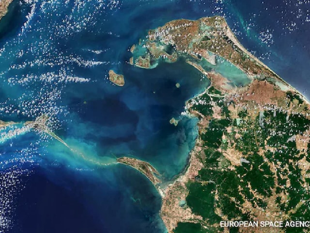
This photograph shared by the European Space Agency (ESA) shows the photo of Ram Setu, a former land bridge connecting India and Sri Lanka. (Image: ESA)
Ram Setu, aka the Adam’s Bridge is a chain of shoals stretching 48 kilometres and at one point of time connected Rameswaram Island in India to Mannar Island in Sri Lanka.
The European Space Agency (ESA) released a photo of the Ram Setu, which is also known as the Adam’s Bridge, located between India and Sri Lanka. The photos were captured by the ESA’s Copernicus Sentinel-2 satellite.
The Adam’s Bridge is a chain of shoals that link India and Sri Lanka and stretches for almost 48 kilometres from Rameswaram Island, off the southeast coast of India, to Mannar Island in Sri Lanka.
The chain of shoals also separates the Gulf of Mannar from the Palk Strait. The Gulf Of Mannar is an inlet of the Indian Ocean to the south while the Palk Strait is an inlet of the Bay of Bengal to the north.
Many theories exist about how this bridge was formed but geological evidence indicates that these limestone shoals are the remains of a landmass that formerly linked India and Sri Lanka.
According to historical records, this natural bridge could be crossed until the 15th century. After that, it slowly eroded because of storms, the ESA said. The space agency also said that some sandbanks in the Ram Setu are dry, and the sea in this area is very shallow, with depths ranging from 1 to 10 metres, as shown by the light colour of the water.
Mannar Island, which is about 130 square kilometres in size, is linked to mainland Sri Lanka by a road bridge and a railway bridge. These bridges can be seen at the southern end of the island.
On the Indian side, there is Rameswaram Island, also called Pamban Island. To reach this island from the Indian side, one must cross the 2-kilometre-long Pamban Bridge. This bridge connects the two lands and enables the transfer of people and goods.
Rameswaram Island, also known as Pamban Island, features two primary towns: Pamban, located on the western edge, and Rameswaram, situated approximately 10 kilometres east of Pamban.
Both sections of Adam’s Bridge are incorporated into protected national parks in India and Sri Lanka. The sand dunes in these parks provide essential breeding grounds for bird species like the brown noddy.